Hampta Pass
Hampta Pass is the most delightful treks in the Manali region, located in Himachal. It is a moderate trek with a scope for varying the duration to suit ones time. Hampta Pass Trek takes us over the majestic foothills of the Himalaya, the Pir Panjal Range, crossing at Hampta Pass (14100 Ft.) –
See more at: http://renokadventures.com/558/hampta-pass-trek/#sthash.XZJIXucd.dpuf
Here goes the itinerary for Hampta Pass Trek
Itinerary Detail
Manali
Day 0 Departure
Meet up at Janpath (near Connaught Place) and leave for Manali by Volvo bus. Overnight Journey.
Chika Day 1
Drive from Manali to Jobra than start trek to Chika (10100 ft)

After breakfast we drive from Manali to Jobra and start our trek to Chika(10,100 feet). While trekking we can see the Rani river on one side and a big rocky hill on the other. Overnight stay at Chika.
Balu Ka Ghera Day 2
Chika (10100 ft) to Balu ka Ghera (11900 ft) .5 hrs easy ascent.

The third day trek is a gradual ascent. While trekking we will be able to see the spectacular Dauladar range. We have lunch in Balu Ka Gera.
Siagoru Day 3
Balu ka Gera (11900 ft) to Siagoru (12900 ft) Crossing Hampta Pass (14100 ft).
This is the most spectacular part of the trek as we cross the Hampta Pass and then descend to our camp site in Siagoru. It will take us approximately 8hrs to reach Siagoru. The ascent on this part of the trek will be moderate.
Chandra Tal Day 4
Siagoru (12900 ft) to Chatru (11000 ft) 4 hrs. Drive to Chandra Tal.

This day we have an easy descent through the Hampta Valley. The massive mountains of the Pir Panjal and Spiti ranges dominate the entire landscape till the camp site at Chatru. Chatru is a confluence point of paths from Rohtang Pass, Hamta Pass and Spiti. From Chatru if road and weather condition permit we head to the Chandra Tal camp site.
Drive from Chandra tal to Manali via the Rohtang Pass
In the morning after breakfast we leave for Manali via the Rohtang Pass. Trek ends
– See more at: http://renokadventures.com/558/hampta-pass-trek/#sthash.XZJIXucd.dpuf
26.917000
75.817000
Tags: hampta pass, Hamta pass, hiking himalayas, hiking the himalayas, himalaya tours, himalaya trek, himalaya trekking, himalaya trekking holidays, himalaya trekking india, himalaya trekking tours, himalaya treks, himalayas hiking, himalayas trek, himalayas trekking, india himalaya trekking, indian himalaya trekking, Manali, manali trekking, nepal himalaya trekking, trek himalaya, trek himalayas, trek in himalayas, trek the himalayas, trekking himalaya, trekking himalaya india, trekking himalayas, trekking himalayas india, trekking himalayas nepal, trekking in himalaya, trekking in himalayas, trekking in manali, trekking in the himalayas, trekking india himalaya, trekking indian himalayas, trekking nepal himalaya, trekking the himalayas, treks himalaya, treks in himalayas
Dayara Bugyal – The biggest meadow of Uttarakhand
Bugyal in the local mountain dialect means “High Altitude Meadow”. Trekking to Dayara Bugyal is one of the most beautiful places in Uttaranchal, situated at an elevation ranging from 10,000 – 12,000 ft. This vast meadow is second to none in natural beauty in Uttarakhand trekking circuit. The possibility of Nordic as well as Alpine skiing are immense here, since during winter it provides one of the best ski slopes in India spread over an area of 28 sq/kms, one can combine a trek and ski during winter trekking season.
Dayara Bugyal trek starts from two places Barsu and Raithal. The road to Dayara Bugyal branches off near Bhatwari- a little township on Uttarkashi Gangotri road about 35 kms. From Uttarkashi, Vehicles can go up to the village of Raithal from where one has to trek a steep incline covering a distance of about 7 kms to reach Dayara and the other route is via village Barsu, 10 kms from Bhatwari from where one has to trek about 8kms to Dayara Bugyal.

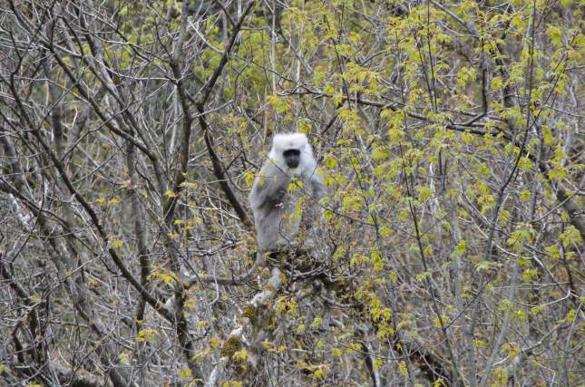
Gray langurs or Hanuman langurs, the most widespread langurs of South Asia, are a group of Old World monkeys constituting the entirety of the genus Semnopithecus.

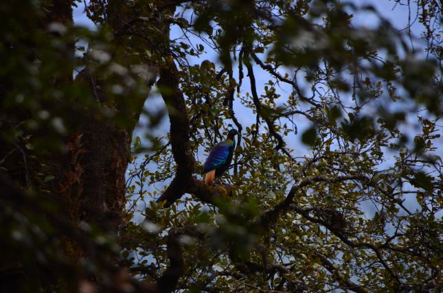
Monal – State Bird of Uttarakhand
This is the best time for birding as all the birds descends from high altitude to lower altitudes due to drop in temperatures.
If some one wants to do this trek here is the ideal itinerary
Day 1 Dehradun to Guest House at Barsu
Arrive at Dehradun/Haridwar in the morning, freshen up, have breakfast and leave for Barsu village Lunch on the way. Arrive at Camp by late afternoon and relax with a hot cup of tea and prepare yourself for trekking in Himalayas. The camp overlooks the Himalayan peaks of Gangotri I, II and III, Jaunli, Draupdi ka Danda and Srikanth.
Days 2 Barsu – Barnala (2700 m) 4 km / 4 hr
Have an early breakfast and get ready for a trekking to Barnala lake (2700 m) about 5 hours away. Trek through the dense forest of Pine and Oak trees. Lunch enroute. Reach Barnala by late afternoon. Explore the forest around the lake and do some bird watching. Barnala is great for bird watching, the most common birds here Whistling Thrush, Red Finch, Monal Pheasant, Koklas etc. Overnight stay in tents.
Day 3 Barnala – Dayara (3250 m) 5 km / 4 hr
Have breakfast and prepare to trek to Dayara. Hot lunch on arrival. The bugyals (meadows), spread over 28 sq kms, are grazing grounds for sheep and cattle and have a 360 degree view of the Himalayas. Spend rest of day walking around the meadows. Overnight stay in tents
Day 4 Dayara – Raithal 7 km / 4 hr
Wake up to a lovely sunrise and walk a little higher for a nice view of Bandarpoonch (6500 mtrs). After breakfast, we will start trekking to village Raithal. Reach camp by early evening. Relax with a hot cup of tea and sumptuous dinner with bonfire. Overnight stay in tents.
Days 5 Raithal – Dehradun / Haridwar
After breakfast leave for Dehradun/Haridwar. Lunch on way, arrive by late afternoon and catch train to go home..
Renok Adventures is having a fixed departure on various dates 3rd November, 10th November and 29th December. For more details please follow the link www.renokadventures.com
26.917000
75.817000
Tags: 25l trekking backpack, action shoes trekking, action trekking shoes, adidas trekking, adidas trekking shoes, adventure india, adventure tourism, adventure tours india, adventure travel india, adventure trekking, adventure trekking holidays, africa trekking, agence trekking, allibert trekking, alpine trekking, alps trekking, annapurna base camp, annapurna base camp trekking, annapurna basecamp trekking, annapurna circuit, annapurna circuit trek, annapurna circuit trekking, annapurna region trekking, annapurna round trekking, annapurna trek, annapurna trekking, annapurna trekking map, annapurna treks, asia trekking, asian trekking, atlas trekking, backpack trekking, backpacks for trekking, backpacks trekking, bali trekking, bangalore trekking club, base camp everest, base camp everest trek, base camp trekking, bata trekking shoes, bergsport, best trekking, best trekking backpack, best trekking backpacks, best trekking bike, best trekking bikes, best trekking gear, best trekking gps, best trekking pole, best trekking poles, best trekking shoes, best trekking watch, best trekking watches, bicycle trekking, bike trekking, bird watching, birding, birding trips, butterfly trekking handlebars, buy trekking poles, buy trekking shoes, camel trekking, camping and trekking, camping trekking, chang mai trekking, charity trekking, cheap trekking shoes, chennai trekking club, chiang rai trekking, clothes for trekking, coorg trekking, darjeeling trekking, define trekking, desert trekking, dharamsala trekking, dhaulagiri trekking, discovery trekking, dolpo trekking, e trekking, ebc trekking, eco trekking, elephant trekking, europe trekking, everest base camp, everest base camp trek, everest base camp trekking, everest base camp treks, everest basecamp trekking, everest region trekking, everest trek, everest trekking, everest trekking map, everest trekking tours, everest treks, extreme trekking, family trekking holidays, food for trekking, ganesh himal trekking, garhwal trekking, ghorepani trekking, glacier trekking, global trekking, globe trekking, go trekking, gokyo lake trekking, gokyo trekking, good trekking shoes, google trekking, gorilla trekking, gorilla trekking safari, gorilla trekking safaris, gps for trekking, gps trekking, grand canyon trekking, great wall trekking, head trekking shoes, helambu trekking, high altitude trekking, Hiking, hiking and trekking, hiking everest, hiking himalayas, hiking holidays, hiking in india, hiking in the himalayas, hiking india, hiking net, hiking poles, hiking the himalayas, hiking tours, hiking trekking, hiking trekking poles, himachal trekking, himalaya, himalaya trek, himalaya trekking, himalaya trekking tours, himalaya treks, himalayan glacier trekking, himalayan tours, himalayan trek, himalayan trekking, himalayan trekking companies, himalayan trekking holidays, himalayan trekking tours, himalayan treks, himalayas trek, himalayas trekking, himalayas trekking tour, holiday trekking, holidays trekking, horse trekking, hybrid trekking bikes, i trekking, ice trekking, india adventure, india hiking, india himalaya trekking, india trek, india trekking, india trekking tour, india trekking tours, india treks, indian himalaya trekking, indian trekking, indian trekking tours, jomsom muktinath trekking, jomsom trekking, jungle trekking, jungle trekking equipment, k2 trekking, kailash mansarovar trekking, kailash trekking tour, kanchenjunga trekking, karakoram trekking, katmandu, kerala trekking, kilimanjaro trekking, kilimanjaro trekking tour, kilimanjaro treks, kodachadri trekking, kokoda trekking, komperdell trekking pole, kumara parvatha trekking, la trekking tent, ladakh india, ladakh tour, ladakh tourism, ladakh tours, ladakh trek, ladakh trekking, ladakh trekking map, ladakh trekking tour, ladakh trekking tours, ladakh treks, ladakh zanskar trekking, ladies trekking shoes, langtang trekking, langtang valley trekking, leh ladakh, leh ladakh trekking, leh trekking, leki trekking poles, light trekking, light trekking shoes, lightweight trekking, lightweight trekking shoes, lonely planet trekking, lukla trekking, luxury trekking, machu picchu trekking, makalu trekking, manali trekking, manaslu trekking, mardi himal trekking, mont blanc trekking, mount everest base camp, mount everest base camp trek, mount everest hiking, mount everest trek, mount everest trekking, mount everest treks, mount kailash trekking, mount kilimanjaro trekking, mountain bike trekking, mountain trekking, mountain trekking equipment, mountain trekking shoes, mt everest base camp, mt everest base camp trek, mt everest trek, mt everest trekking, mt everest treks, mt kailash trekking, mt kilimanjaro trekking, munnar trekking, mustang trekking, nanda devi trekking, nike trekking shoes, nomad trekking, nordic trekking poles, nordic walking sticks, north india trekking, nz hiking, nz trekking, outdoor, outdoor outlet, outdoor shop, outdoor trecking, outdoor trekking, outdoorshop, patagonia trekking, photo trekking, pinatubo trekking, pokhara trekking, pony trekking, poon hill trekking, puma trekking shoes, quad bike trekking, quad trekking, rafting in india, rafting in rishikesh, rafting india, rainforest trekking, randonnee trekking, reebok trekking shoes, review trekking poles, rinjani trekking, rishikesh river rafting, rishikesh trekking, river rafting in rishikesh, river trekking, round annapurna trekking, runescape temple trekking, rwenzori trekking, sakleshpur trekking, salomon trekking shoes, sandakphu trekking, sapa trekking, sherpa trekking, shoes for trekking, shoes trekking, short trekking, sikkim trekking, sikkim trekking routes, simple treks, skandagiri trekking, ski trekking, snow leopard trekking, snow trekking, snow trekking shoes, socks trekking, south india trekking, star trekk, star trekking, star trekking song, swiss trekking, tasmania trekking, temple trekking, thamserku trekking, tibet trekking, tibet trekking tour, tibet trekking tours, tilicho lake trekking, timberland trekking shoes, tissot touch trekking, tissot trekking, top trekking, tours and trekking, tours trekking, training for trekking, tramping, travel insurance trekking, travel trekking, treaking, treck, trecking, tree top trekking, tree trekking, treetop trekking, trek, trek adventure, trek andes, trek annapurna, trek aventure, trek everest, trek everest base camp, trek himalaya, trek himalayas, trek holidays, trek in himalaya, trek in himalayas, trek in india, trek india, trek mount everest, trek the himalayas, trek to base camp everest, trek to everest base camp, trek to himalayas, trek to mount everest, trek tours, treking, trekk, trekke, trekked, trekkes, trekkin, trekking, trekking 2011, trekking accessories, trekking adventure, trekking adventure holidays, trekking adventures, trekking africa, trekking agencies, trekking agency, trekking alps, trekking america, trekking and camping, trekking and hiking, trekking annapurna, trekking annapurna circuit, trekking annapurna nepal, trekking apparel, trekking around annapurna, trekking around mumbai, trekking asia, trekking atlas, trekking attire, trekking backpack, trekking backpacks, trekking backpacks india, trekking bag, trekking bags, trekking bali, trekking bangalore, trekking bars, trekking bicycle, trekking bicycles, trekking bike, trekking bikes, trekking blog, trekking boot, trekking butterfly handlebars, trekking camping, trekking camps, trekking chang mai, trekking chiang rai, trekking clothes, trekking clothing, trekking clubs, trekking companies, trekking company, trekking darjeeling, trekking destinations, trekking equipment, trekking equipment delhi, trekking equipment india, trekking equipment list, trekking equipment mumbai, trekking equipments, trekking europe, trekking everest, trekking everest base camp, trekking expedition, trekking expeditions, trekking experience, trekking fahrrad, trekking fashion, trekking food, trekking footwear, trekking for charity, trekking for kids, trekking gadgets, trekking garhwal, trekking gear, trekking gear india, trekking gear list, trekking gears, trekking gloves, trekking gps, trekking grand canyon, trekking group, trekking groups, trekking guide, trekking guides, trekking handlebar, trekking handlebars, trekking hat, trekking hats, trekking hiking, trekking himachal, trekking himalaya, trekking himalayas, trekking himalayas india, trekking holiday, trekking holidays, trekking holidays in india, trekking holidays india, trekking horse, trekking in africa, trekking in alps, trekking in america, trekking in annapurna, trekking in asia, trekking in bali, trekking in bangalore, trekking in chennai, trekking in coorg, trekking in darjeeling, trekking in dolpo, trekking in europe, trekking in everest, trekking in garhwal, trekking in goa, trekking in himachal, trekking in himachal pradesh, trekking in himalaya, trekking in himalayas, trekking in himalayas india, trekking in hyderabad, trekking in india, trekking in indian himalaya, trekking in karnataka, trekking in kashmir, trekking in kerala, trekking in ladakh, trekking in langtang, trekking in leh, trekking in maharashtra, trekking in manali, trekking in mount everest, trekking in mumbai, trekking in munnar, trekking in mustang, trekking in nz, trekking in patagonia, trekking in pune, trekking in rishikesh, trekking in sapa, trekking in sikkim, trekking in tasmania, trekking in the himalaya, trekking in the himalayas, trekking in the himalayas india, trekking in the mountains, trekking in tibet, trekking in uttarakhand, trekking in uttaranchal, trekking in zanskar, trekking india, trekking india himalaya, trekking indian himalaya, trekking indian himalayas, trekking insurance, trekking jacket, trekking jackets, trekking jobs, trekking jungle, trekking kerala, trekking kilimanjaro, trekking kit, trekking kokoda, trekking ladakh, trekking ladakh zanskar, trekking langtang, trekking leh, trekking machu picchu, trekking machu pichu, trekking magazine, trekking magazines, trekking maps, trekking meals, trekking meaning, trekking monopod, trekking mont blanc, trekking mount everest, trekking mount kilimanjaro, trekking mountain, trekking mountains, trekking mt everest, trekking mt kilimanjaro, trekking mumbai, trekking near bangalore, trekking near mumbai, trekking nz, trekking outdoor, trekking outfit, trekking pack, trekking packages, trekking packs, trekking pant, trekking pants, trekking pants men, trekking pants women, trekking patagonia, trekking peak, trekking peaks, trekking photos, trekking pokhara, trekking pole, trekking pole review, trekking pole reviews, trekking poles, trekking poles leki, trekking poles review, trekking poles reviews, trekking rinjani, trekking routes, trekking routes in india, trekking rucksack, trekking rucksacks, trekking saddle, trekking sandals, trekking sandals men, trekking sapa, trekking shirts, trekking shoe, trekking shoes, trekking shoes adidas, trekking shoes bangalore, trekking shoes brands, trekking shoes delhi, trekking shoes india, trekking shoes mumbai, trekking shoes review, trekking shoes sale, trekking shoes women, trekking shop, trekking shops, trekking sikkim, trekking sites, trekking sleeping bag, trekking sleeping bags, trekking sock, trekking socks, trekking solo, trekking stick, trekking sticks, trekking stores, trekking stove, trekking sunglasses, trekking supplies, trekking t shirts, trekking tasmania, trekking tent, trekking tents, trekking the alps, trekking the amazon, trekking the himalayas, trekking tibet, trekking tips, trekking to everest, trekking to everest base camp, trekking to himalayas, trekking tour, trekking tour india, trekking touren, trekking tours, trekking tours in india, trekking tours india, trekking training, trekking travel insurance, trekking trekking, trekking trip, trekking trips, trekking trips in india, trekking trousers, trekking trousers women, trekking vacation, trekking vacations, trekking walking, trekking watch, trekking watches, trekking wear, trekking websites, trekking wiki, trekking world, trekking y hiking, trekkingbike, trekkingrad, trekkingtour, treks, treks himalaya, treks in himalaya, treks in himalayas, treks in india, treks india, treks international, treks to himalayas, tsum valley trekking, upper dolpo trekking, upper mustang trekking, uttarakhand trekking, uttaranchal trekking, vibram trekking, volcano trekking, voyage trekking, voyages trekking, walking, walking himalayas, walking in the himalayas, walking poles, walking trekking, walking trekking holidays, walking trekking poles, waterproof trekking shoes, what is trekking, wilderness trekking, winter trekking, women trekking shoes, worldwide trekking, youth hostel trekking, zanskar trek, zanskar trekking


